Comparison of georadars in the study of the road clothes
29 July 2019

Fig. 1. The experimental testing ground and GROT 12H georadar with Wi-Fi module.
Timer LLC took part in a joint research work organized by The State Company Russian Highways (Avtodor) and FAU ROSDORNII (Russian Highway Research Institute of Ministry of Transport) at the experimental testing ground for testing geosynthetic materials: "A-107 Highway Moscow Small Ring between Kiev and Minsk Highways, near Kobyakovo village and NII Radio township".
Based on the previously conducted FAU ROSDORNII survey in 2018, it was concluded that there is a correlation between the GPR readings and the falling weight deflectometer.
Therefore, it was decided to conduct additional joint tests in order to search for additional opportunities for the joint use of ground penetrating radars and falling weight deflectometers, as well as evaluation the possibility of detection of road sections with reduced modulus of elasticity and location of the weakening areas in the layers of the road structure, using georadar study.
Experimental training ground was created in 2016 for tests of geosynthetic materials for reinforcing road base layers’ clothes. Its length is 720 m.
The control section was built in order to evaluate the effectiveness of the use of geosynthetic materials in road clothes.
During the construction process, a layer-by-layer quality control of construction was carried out at each experimental section using a dynamic and static plate loading test and a falling weight deflectometer.
To assess the homogeneity of pavement, a study using various GPR equipment was carried out on July 29, 2019.
In the georadar tests, 7 organizations with various models of georadar took part (Fig. 2).

Fig. 2. Participants in the georadar research (a fragment of the ROSDORNII report, in Russian).
Simultaneously with field georadar works, in order to verify the results, drilling and coring were performed. Drilling of the gravel-sand layer was performed after dismantling the asphalt-concrete layers. The pits were dug by an excavator after partial dismantling of the gravel-sand layer.
Our company showed the most successful results in the task of localization of dynamic deflection decrease zones and other anomalies in road clothes.
According to the results of correlation assessment of the results of georadar data with the falling weight deflectometer data (Figs. 3 and 4), Timer LLC obtained excellent results: the use of GROT 12H georadar helped to localize zones of the dynamic deflection decrease and, as a result, zones of the elastic modulus increase!

Fig. 3. Fragment of the ROSDORNII report: comparison of the obtained correlation data for anomalies detected in the right lane of the road (in Russian). Timer LLC data are in the last right column.
As can be seen from the table (Fig. 2), the frequency range of the georadar set used by Timer LLC is much lower than that of FAU ROSDORNII, GEORADAR + EXPERT and NPO TERRAZOND, i.e. the obtained result indicates that the design features of GROT 12 georadar allow us to compensate dependence of resolution on the frequency range of antennas with the possibility of direct measurements of the amplitude of the reflected signal, which is not subjected to distortion due to neither frequency nor time gating.
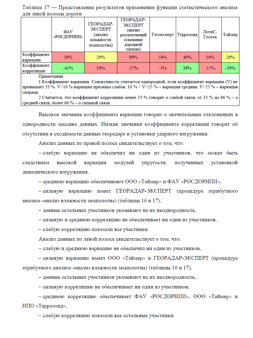
Fig. 4. Fragment of the ROSDORNII report: comparison of the obtained correlation data for anomalies detected in the left lane of the road (in Russian). Timer LLC data are in the last right column.
Graphs that clearly demonstrate the dependence of the dynamic deflection on the location of the anomalies identified by the participants for the right (forward) and left (reverse) lanes of the road are shown in Figures 31 and 32 (numbering of the report). Timer LLC data marked green.


Figures 33 and 34 (numbering of the report) show locations of anomalies, detected by all participants (33 is for right lane, 34 is for left lane of the road). Timer LLC data marked green.


In conclusion of the research work, the specialists of the ROSDORNII made, in particular, the following conclusions:
1) GPR equipment allows to determine the thickness of the layers of the road structure. The indicated problem was best solved by georadars designed to work separately from the surface.
2) The location of the anomalous zones was also identified by the entire line of georadars used, while the best results were obtained with those that have a surface contact antenna.
3) There is a convergence of the results of the georadar survey in terms of the location of the anomalous zones and the results of measuring of the dynamic deflection using falling weight deflectometer.
ROSDORNII report (in Russian) is available from: